


Overview
When a major crisis strikes, Visit California's response helps visitors and residents stay safe and accelerates the return of the tourism dollars that are vital for economic recovery.
Visit California was formed in the aftermath of two devastating earthquakes – Loma Prieta in 1989 and Northridge in 1994. These earthquakes devastated the state in both physical and economic damage. The quakes devastated the state physically and all Californians emotionally and economically. Tourism numbers rapidly declined, and it became obvious that a new approach to marketing California as a unified destination was necessary. While much of the program of work focuses on inspiring leisure travel to California, another critical component is messaging in the face of crisis and natural disasters that can include earthquakes, heavy snow, floods, road closures, wildfires and more.
Visit California’s role is to reassure travelers that California is open and to provide them with current, reliable and level-headed information. When disasters occur, the organization uses a crisis evaluation matrix to assess potential impacts on tourism. Travel alerts are published on VisitCalifornia.com to keep travelers and the industry connected to authoritative information. When necessary, Visit California works with the Governor’s Office of Emergency Services and Caltrans to connect people to reliable updates.
Accelerating recovery
Visit California addresses varied crises with on-the-ground response and recovery marketing
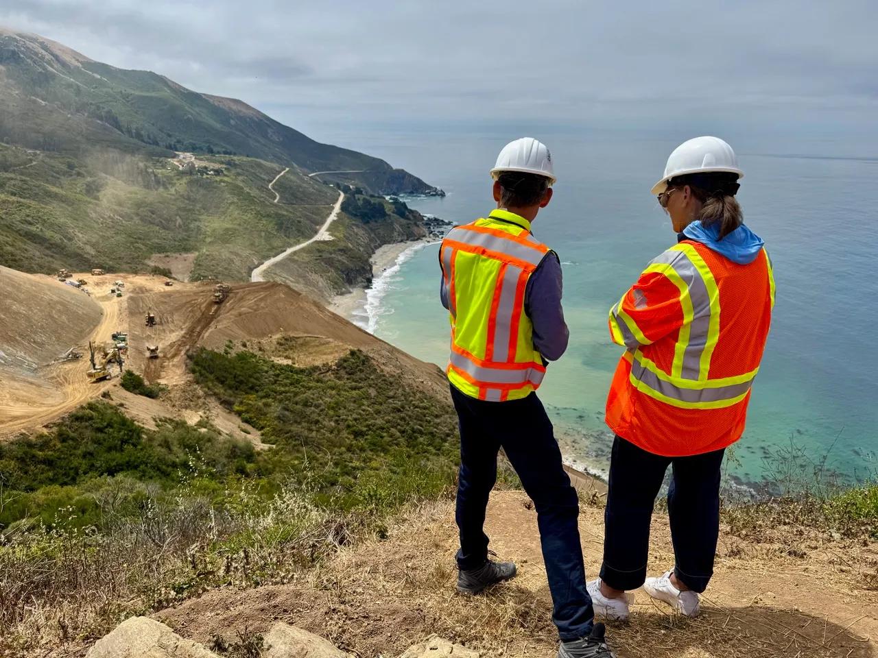
Highway 1 repairs coordination
July 2025, Caltrans District 5 Director Scott Eades briefs Visit California President & CEO Caroline Beteta from the top of Regent’s Slide 650 feet above Highway 1. This close relationship helps Visit California keep partners, travelers and media updated with accurate information.
'Love LA' Palisades wildfire recovery
In coordination with Los Angeles Tourism, Visit California launched the "Love LA" campaign encouraging visitation to the majority of the city that had been untouched by the 2025 Palisades fire.

2017 Wine Country wildfires recovery
Visit California invited California celebrities and chefs for a shared meal to show solidarity with Wine Country businesses and signal the region's resilience to the world. Chef Curtis Stone pictured.
COVID-19 Response
Visit California prioritized public safety and respectful visitation by distributing "Responsible Travel Code" collateral, while the "Calling All Californians" campaign increased in-state tourism to help sustain local businesses during travel restrictions.
Crisis committees
Visit California convenes its crisis communications task force with affected communities to share impacts of natural disasters and develop strategies. The task force maintains a Crisis Communications Plan and, in the past, has collaborated on open-for-business campaigns when stricken communities are ready to receive visitors.
Similarly, Visit California convenes its snow committee twice a year with its committee members who represent mountain destinations. This coordination is vital when informing the public and businesses about complex, evolving road closures, such as along Highway 1.
Real-time information
Emergency preparedness apps don’t just help travelers stay safe, they combat misinformation in the fast-moving news cycles around ongoing disasters. The apps recommended here provide real-time data from government monitoring of on-the-ground imagery. These are all free and easily accessed.

West Coast Travel Facts
Visit California partnered with Travel Oregon and Washington Tourism to develop West Coast Travel Facts. Visitors to the site can find accurate information about West Coast fires. Click “Current Conditions” to see a map of the West Coast displaying real-time air quality index as well as live cams and, when needed, alternate route suggestions.
EPA AirNow app
The U.S. Environmental Protection Agency’s AirNow mobile app is a valuable tool to quickly determine the air quality index, which can be negatively affected by wildfire smoke and extreme heat. AirNow can help travelers stay safe with an extra layer of information in a state that is known for its great outdoors.
MyShake app
Earthquake preparation remains imperative to protect businesses, employees and customers. New technology can generate early earthquake warnings, which can allow people to take cover before the shaking starts. The California Governor’s Office of Emergency Services encourages tourism partners to sign up and download the MyShake app for free.
Wireless emergency alerts
The California Governor’s Office of Emergency Services issues short text messages to your phone during all imminent threats, including earthquakes, fires and floods. It’s a free service and takes only a few minutes to subscribe.
View more campaigns